68° 44' 17" N 133° 26' 26" W
Lead Investigator: Phil Marsh (e-mail: www)
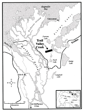
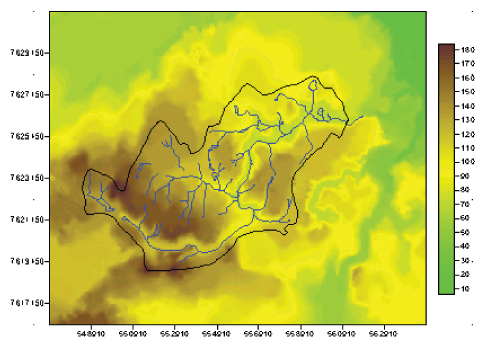
Trail Valley Creek is located 55 km north-northeast of Inuvik, just to the east of the Mackenzie River Delta. It drains an area of approximately 58 km², flowing in a generally north-westerly direction through the Eskimo Lakes system into the Arctic Ocean. The basin is dominated by gently rolling hills with some deeply incised river valleys, covered primarily with sparse and shrub tundra and tundra ponds, underlain by continuous permafrost; elevations range from 50 to 180m above sea-level, and the mean slope is 3º.
The basin is within the zone of continuous permafrost, with maximum thickness estimated at 350 to 375m, and observed active layer depths reaching 0.3 to 0.8 m (Marsh and Pomeroy 1996). Soils are organic cryosols consisting of an upper peat layer ranging in thickness between 0.2 and 0.5m underlain by a mineral, silty clay soil.
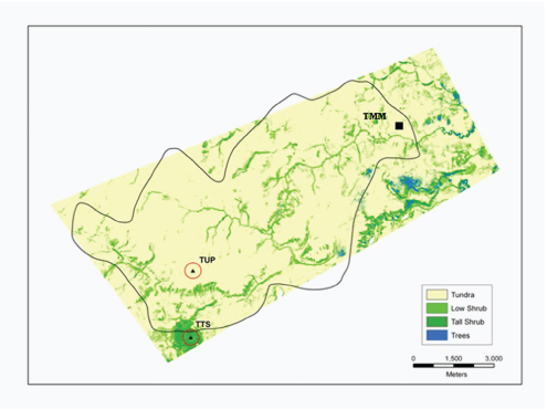
The basin is located at the northern edge of the boreal forest – tundra ecotone. Vegetation of the dominant upland open tundra areas consists mostly of grasses, lichens (Lecidea) and mosses (Sphagnum), while moister hillslopes and valley bottoms support shrub tundra, with 0.5 to 3m high alder (Alnus), birch (Betula), and willow (Salix) shrubs, and sparse pockets of black spruce (Picea mariana) forest. Vegetational land cover in the study area was determined from summer Landsat TM images at a resolution of 20 m.
The climate of the region is characterized by short summers and long cold winters, with an eight-month snow-covered period (Environment Canada). Much of the annual precipitation (66% at Inuvik) is comprised of snow, which accumulates over the winter, and is subsequently released over a relatively short time period during spring snowmelt.
Data
have been
collected from three permanent meteorological stations, shown on the map, with
supporting data from two streamflow gauging stations;
TMM is located on a level open tundra surface at UTM coordinates 8W 560605, 7626818
(68º 44.78" N 133º 30.11" W, approx)
at an elevation of about 85m above sea level.
TUP is located on a level open tundra surface on a higher elevation plateau at
UTM coordinates 8W 552817, 7620762 (68º 41.62" N 133º 41.84" W, approx) at an elevation of about 160m above sea level.
TTS is located in an area of higher alder and willow shrubs just to the south of
the actual basin (68º 40.23" N 133º 42.03" W, approx; 145m, approx). There are sensors above and below the shrub canopy.