60º 32’ N 135º 07’ W The basin is
situated within the Boreal Cordillera ecozone (Environment Canada, 1995), and
consists of three principal ecosystems; boreal forest (22%), sub-alpine taiga
(shrub-tundra) (58%), and alpine tundra (20%). Permafrost is present on north
facing slopes and sporadically throughout the basin, with prevalence increasing
with elevation.
Alpine Tundra met station
Lead
Investigator: Sean Carey (e-mail: www)
The
Wolf Creek basin forms part of the southern headwaters of the Yukon River, among
mountains some 20km south of Whitehorse. The basin drains
an area of approximately 195km², ranging in elevation from 800 to
2250m, with the median at 1325m, and a general north-easterly aspect.
The sub-arctic continental climate is characterized by wide seasonal variation
in temperature, low relative humidity and relatively low precipitation. Mean
annual temperature is approximately -3ºC, with summer monthly ranges of 5ºC -
15ºC, and and winter monthly ranges of -100ºC to -20ºC. Summer and winter
extremes of 25ºC and -40ºC are not uncommon. Mean annual precipitation is 300 to
400 mm per year, with approximately 40% of this falling as snow.
Three micrometeorological stations (Alpine Tundra, Buckbrush Taiga, and White
Spruce Forest) were established to collect and store weather and soil data. A
hydrometric station located at the Wolf Creek basin outlet nearby the Alaska
Highway was used to record the basin discharge. Several additional sites were
also established in a sub-basin (the Granger Basin, approximate area 4.3 km²),
in order to study energy and water balances on sloped surfaces. Three sub-basins
are gauged for streamflow.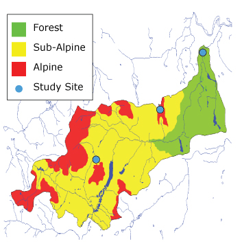
Location: 60°34.04 N 135°08.98 W
Elevation: 1615 m
Area represented: 39 km² (20% of basin total)
Description: Windswept, high alpine tundra plateau along the
drainage divide at the northern edge of the basin. Approximately 50% of the site
is relatively level, with the balance sloping at approximately 15º to the south.
A reasonably level fetch extends for several hundred meters to the north, south,
and west. A rounded hilltop (35m) rises about 50m to the east. Vegetation is
sparse and consists of mosses and lichens with occasional patches of scrub
willow and birch no more than 20 cm tall. Boulders up to 1m tall are scattered
on the plateau. Soils are lichen moss organic for the top 3cm, with a
rocky/bouldery mineral soil below.
Buckbrush Taiga met station
Location: 60°31.34 N 135°11.84 W
Elevation: 1250 m
Area represented: 113 km² (58% of basin total)
Description: Located on an east-facing moderate hillslope of
approximately 15º, near the bottom of the valley between Mt Granger and Coal
Ridge, on a drainage divide between the Coal Lake Basin and the highest
headwater of Mt Granger. A sloping fetch extends NE and SW for several
kilometres. To the NW, the valley slopes upwards and to the SE the valley drops
somewhat before rising to Coal Ridge. The hillslope itself consists of
undulating terrain with numerous hummocks and depressions. Vegetation is
bushy, consisting of tall willows and alders (1-3 m) with sparsely scattered
spruce (spaced about 100 m apart). Top 6cm of soil is moss organic, with an
alluvial fan of rocks and silt below.
moss organic, below this an alluvial fan of rocks and silt.
The station comprises a 5.2m tower micrometeorological array, using solid state
Campbell Scientific Inc dataloggers with data-storage modules. Power is supplied
by 12V DC batteries, charged by solar modules.
White Spruce Forest met station
Location: 60°35.76 N 134°57.17 W
Elevation: 750 m
Area represented: 43 km² (22% of basin total)
Description: The study area includes three data-collection sites
on a relatively level valley bottom, set in dense canopy of mature white spruce
forest (12 - 18m) with some poplar trees (to approximately 15m), close to the
Wolf Creek basin outlet. The terrain undulates gently, consisting of an
alternating hummock and hollow landscape. The forest extends in all directions,
except for the area occupied by the Whitehorse Cadet Camp, some 50 m NE of the
Site 1 mast. A 10m wide clearing 15m west of the Site 3 tower allows for
canopy-free precipitation measurements. Soils are
moss organic in the top 10 - 15cm, underlain by silt loam to 1.4m, with river
gravel below this.
The towers are 22m and 15m tall, with a micrometeorological sensor array writing
to solid state Campbell Scientific Inc dataloggers with data-storage modules.
Power is supplied by 12V DC batteries, charged by solar modules.