Outlines of the Mackenzie Basin
and its six major subbasins
Last Updated: September 2 1999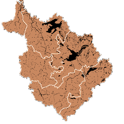
The data in the following .zip files are provided as a courtesy of Research Scientists at the National Hydrological Research Institute of Saskatoon. The files are in SPANS GIS compatible format .vec (vector data) and .veh (header) files. Further information on the data format is available. To download the files click on the basin in the image above or select the basin from the list below:
However, SPANS is not necessary to read these files since they contain ASCII text and are easily displayed and understood using any word processor. The vector coordinates are found in the .vec files. The .veh files are SPANS header information. The .vec file values are easily recognizable as decimal longitudes and latitudes, one pair per line.
Gary Weiss (ECB Regina) has converted the basin outlines from the SPANS raster format into ESRI's Arcview file format. These files are available via the link below.
| Size (KB) | Zip filename | Contents of unzipped files (.vec & .veh) |
|---|---|---|
| 124 | athbasca.zip | Athabasca River basin outline |
| 118 | bear.zip | Great Bear Lake basin outline |
| 102 | liard.zip | Liard River basin outline |
| 113 | peace.zip | Peace River basin outline |
| 34 | peel.zip | Peel River basin outline |
| 135 | slave.zip | Great Slave Lake basin outline |
| 131 | basinvec.zip | Outline of the whole Mackenzie basin |
| (.dbf, .sbn, .sbx, .shp, & .shx) | ||
| 898 | Mackenzie_basins.zip | Outline of the Mackenzie basin/sub-basins in Arcview format |
Historical data of the discharge amounts and the date of freeze up and breakup of the ice on the Mackenzie River are also available.
