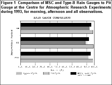
Goodison and Louie (1986) reported that the difference in gauge catch for the MSC and Type-B rain gauges compared to pit gauge measurements at three test sites in Canada averaged 4% low for the MSC and 1% low for the Type-B. Although these tests provided some basic information on the magnitude of the systematic errors compared to the reference pit gauge for three climatic regions, no interpretation of the differences was attempted. Both gauges are mounted relatively low to the ground to reduce the effect of wind on gauge catch. The Type-B gauge was designed to minimize systematic errors, particularly losses due to adhesion of water to the gauge surface, evaporation between measurement periods and splash out. Ongoing intercomparison of AES rain gauges at t he Centre for Atmospheric Research (CARE) near Toronto, Ontario confirms that the systematic difference between the Type-B gauge mounted at 40 cm and the pit gauge is about 2% lower at an open windy site (Figure 1).
Wetting loss is defined as water subject to evaporation from the surface of the inner walls of the precipitation gauge after a precipitation event and water retained on the walls of the gauge and its containers after its emptying. Laboratory experiments a nd field investigations by Metcalfe and Routledge (1994) have shown that wetting and evaporative losses for the MSC gauge can be quite large. The average retention loss for the MSC gauge used prior to 1965 (i.e. all copper inserts) is .36 mm per observati on. The average retention loss for the post 1965 period when the plastic insert was used was only .17 mm. Although it is estimated that evaporative losses can also be significant for this gauge, it is difficult to measure and for principal and synoptic st ations it is probably small since observations are made at shorter intervals than at climatological stations. Figure 1 compares the catch of the MSC, with plastic insert, and Type-B rain gauges to the pit gauge at CARE and also shows the effect of correct ing the MSC gauge for wetting loss. Even with correction for wetting loss the MSC gauge measured an average of 5% below the pit gauge. CARE is a climate station which makes two observations a day (i.e. AM and PM). There is a noticeable difference in measu red MSC totals compared to the pit gauge between morning and afternoon observations. The lower ratio for the PM observation could be due to evaporation but this has not been confirmed by any experimental studies.
Goodison and Metcalfe (1981) reported on an experiment to measure fresh snowfall water equivalent at selected Canadian stations over a three year period. Seasonal average fresh snowfall densities ranged from 70 to 165 kg m-3 across Canada. Recent results from Dease Lake, BC, an evaluation station in the WMO Intercomparison and a study site in the fresh snowfall experiment, produced a mean density of 81 kg m-3 which was calculated from comparative reference gauge/ruler ratios over five winter seasons. This value corresponded favourably to average densities of 71 to 84 kg m-3 determined in the previous study (Goodison and Metcalfe, 1981). Use of the standard 100 kg m-3 mean density at this station results in a 20% overestimation of winter precipitation. This is quite the opposite from most gauge measurements and from the common perception of most hydrologists.
The Canadian Nipher Shielded Snow Gauge System has been designated as the standard AES instrument for measuring snowfall amount as water equivalent. The accuracy of this snow gauge and others used in Canada was first defined by Goodison (1978). Results fr om the WMO Intercomparison indicate results similar to those found previously and show the catch of the Canadian Nipher shielded gauge to be almost the same as the WMO reference standard (Goodison and Metcalfe, 1992).
The Canadian Nipher gauge is a non-recording gauge requiring the melted contents to be poured out into a measuring graduate. There is a wetting loss as the gauge always retains a certain amount of water which cannot be poured out. Previous field experimen tation (Goodison, 1978) determined an average wetting loss for the Nipher gauge collector of 0.15 mm +/- 0.02 mm. Recent studies (Goodison and Metcalfe, 1989), as part of the WMO Intercomparison experiment, confirm these findings, with older collectors showing even greater wetting loss. This is a systematic error which occurs every time the contents are melted and poured out of the gauge.
The measurement of "trace amounts" of precipitation (<0.2 mm) using the Nipher gauge is also a concern. Some Arctic stations have reported over 80% of all precipitation observations as trace amounts. A trace is assigned a value of zero in the AES digital archive. Using techniques similar to those described above for resolving wetting loss, it was determined that a trace could be an actual measurable amount, the value of which lies between 0.0 mm and 0.15 mm. For correction purposes a trace re ported in any 6-hour period is assigned a value of 0.07 mm. In the Arctic, where there is a high incidence of ice crystals reported, each trace is assigned an even lower value of 0.03 mm. Woo and Steer (1979) suggested similar values for Arctic trace rain fall.
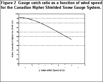
Many investigators have indicated that wind is a major cause of error in precipitation gauge measurements (Goodison et al., 1981). The effect of wind on gauge catch can be reduced by the use of naturally sheltered locations, or by using artificial shielding. Goodison (1978) showed that for most gauges, the mean ratio of gauge catch to "true precipitation" as a function of wind speed decreases exponentially with increasing wind speed. The Canadian Nipher gauge was an exception. The unique design of the Canadian Nipher shield minimizes disturbance of the airflow over the gauge and eliminates updrafts over the orifice. This results in an improved catch by the gauge, for wind speeds up to 7 ms-1, measured at gauge height, relative to other shielded and unshielded gauges (Goodison et al., 1983). Results from the WMO Intercomparison, shown in Figure 2, confirm Goodison's findings but show the catch efficiency of the Nipher to be generally lower than that reported by Goodison (1978). Considering that two quite different methods of determining "true precipitation" were used and that the WMO Intercomparison involved sites in several different climatic regions, the results from these two studies are quite comparable.
For wind speed, the element used is the reported hourly wind speed
measured as a two minute average recorded on the hour. From these, the
mean wind speed for the 6 hour period corresponding to the time of the
precipitation observation is determined. The station wind speed, which is
typically located at 10 m above ground surface, is then estimated for a
Nipher gauge orifice height of 1.5 m according to the following
formulae:
	Uhp = (log hzo-1) (logHzo-1)-1  (1 - 0.024 a) UH
where:
	Uhp	wind speed at the height of the gauge orifice
h	above ground, Nipher=1.5 m
zo	roughness length: 0.01 m for winter
H	height of the wind speed measuring instrument above ground, normally 10 m
UH	wind speed measured at the height H above ground
a	average vertical angle of obstacles around the gauge
The latter (µ) depends on the exposure of the gauge site and is based on a technique for classifying exposure of a site as recommended by Sevruk (1994) using station descriptions stored in the AES archives.
In order to adjust snow water equivalent (SWE) measurement at AES stations for periods prior to Nipher gauge measurements, a mean density is calculated based on the ratio of corrected Nipher gauge measurement to snowfall measurement for storms of 5.0 mm or greater during the period of record when snow ruler and gauge measurements were made coincidentally. This calculated density is then used to go back and correct the 24 hour precipitation total amounts prior to gauge measurement. To correct AES stations which have only snow ruler measurements (i.e. no Nipher gauge) average regional densities based on the above procedure will be used to interpolate new average station density. Table 1 shows average snow densities for different climatic regions within the NWT derived by this method.
| Region | Mean Snowfall Density |
|---|---|
| High Arctic | 108 kg m-3 |
| NWT barrens (east of longitude 110 ) | 145 kg m-3 |
| NWT barrens (west of longitude 110 ) | 137 kg m-3 |
| Mackenzie (delta area) | 106 kg m-3 |
| Mackenzie (Norman Wells to Great Slave Lake) | 112 kg m-3 |
| Baffin Island | 125 kg m-3 |
Most important, however, is that both methods indicate that actual annual precipitation is 50 - 100% greater than measured at this station. Similar increases resulted when precipitation corrections were made at other Arctic stations. Increases in corrected annual precipitation totals were less dramatic for other NWT stations located south of 65 N. For example, at Yellowknife corrections increased average annual precipitation by 26% and at Norman Wells by 19%. Both these sites are more sheltered than Resol ute and the effect of wind on gauge catch is less.
The primary reason for the larger differences between measured and corrected precipitation at High Arctic stations is the number of traces recorded annually at these locations. At Resolute Bay the average number of traces recorded each year has continued to increase from around 300 in 1950 to well over 700 in 1993. A large number of these trace observations are a result of the occurrence of ice crystals. There is some speculation that this trend in ice crystal occurrence may be directly or indirectly rela ted to a systematic increase in Arctic haze and to changes in the Arctic winter boundary layer (Bradley et al., 1993).
The major source of water in NWT basins is precipitation. To estimate flows and to regulate the construction of holding ponds, accurate input values of all environmental parameters to the water balance equation must be available to users in both industry and government. The correction of six hourly archived precipitation measurements for known systematic errors will provide significantly improved estimates of actual precipitation than are currently available. It is anticipated that anomalies currently existing between various hydrologic data sets will be minimized after correction of the precipitation archive.
Goodison, B.E., 1978. "Accuracy of Canadian snow gauge measurements", J. Appl. Meteorol., 27, 1542-1548.
Goodison, B.E., 1981. "Compatibility of Canadian snowfall and snow cover data", Water Resources Research, 17, 4, 893-900.
Goodison, B.E. and Metcalfe, J.R. 1981. "An experiment to measure fresh snowfall water equivalent at Canadian climate stations", Proc. 38th Eastern Snow Conference, Syracuse, NY, USA, 4-5 June, 1981, 110-112.
Goodison, B.E. and Louie, P.Y.T. 1986. "Canadian methods for precipitation measurement and correction", Proc. International Workshop of Correction of Precipitation Measurements, Zurich, Switzerland, 1-3 April, 1985, 141-145.
Goodison, B.E. and Metcalfe, J.R. 1989. "Canadian Participation in the WMO Solid Precipitation Measurement Intercomparison: preliminary results", WMO/IAHS/ETH Workshop on Precipitation Measurement, St. Moritz, Switzerland, 3-7 Dec., 1989, 121-125.
Goodison, B.E. and Metcalfe, J.R. 1992. "The WMO Solid Precipitation Measurement Intercomparison: Canadian assessment", WMO Technical Conference on Instruments and Methods of Observation (TECO-92), Vienna, Austria, 11-15 May, 1992, 221-225.
Goodison, B.E., Elomaa, E., Golubev, V., Gunther, T. and Sevruk, B. 1994. "The WMO Solid Precipitation Measurement Intercomparison: Preliminary Results", WMO Technical Conference on Instruments and Methods of Observation (TECO-94), Geneva, Switzerland, 28 Feb.- 2 Mar., 1994, 15-19.
Metcalfe, J.R. and Goodison, B.E. 1993. "Correction of Canadian Winter Precipitation Data", Eighth Symposium on Meteorological Observations and Instrumentation, 17-22 January 1993, Anaheim, California, 338-343.
Metcalfe, J.R. and Routledge, B. 1994. "AES Standard Rain Gauge: An Evaluation", in preparation.
Sevruk, B. 1994. "Correction Procedures for Precipitation Measurements", Document 32, CIMO XI, Geneva.
Woo, Ming-ko, Heron, R., Marsh, P. and Steer, P. 1983. "Comparison of Weather Station Snowfall with Winter Snow Accumulation in High Arctic Basins", Atmosphere-Ocean, 21(3) 1983, 312-325.
Woo, Ming-ko and Steer, P. 1979. "Measurement of Trace Rainfall at a High Arctic Site", Arctic, 32, 1 (March 1979), 80-84.