
Related items loading ...
Section 1: Site Overview
Research Site Name
Dadongshu Yakou (Binggou River) Research Site #1
Research Site ID #
Catchment Name
Dadongshu Yakou (Binggou River)
Primary Contacts
Site Location
|
Coordinate Format
|
Latitude
|
Longitude
|
|
Degrees Minutes Seconds
|
See catchment
|
|
|
Decimal Degrees
|
|
|
Elevation
|
Minimum
|
Maximum
|
|
See catchment
|
|
Additional Features of this Site
Additional Information (notes, web addresses, etc.)
Section 3: Forcing Data
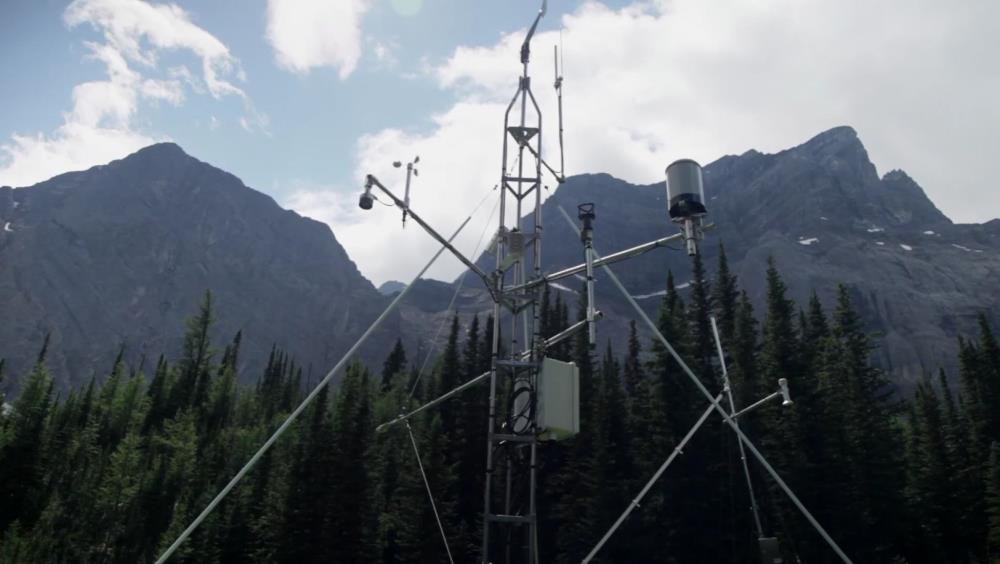
Standard Forcing Variables
|
Forcing Variable
|
Instrumentation Description
|
Temporal Resolution
|
|
T
|
Vaisala-HMP45C
|
|
|
RH
|
Kipp&Zonen-CNR1
|
|
|
K in
|
Kipp&Zonen-CNR1
|
|
|
K out
|
Kipp&Zonen-CNR1
|
|
|
L in
|
Kipp&Zonen-CNR1
|
|
|
L out
|
Kipp&Zonen-CNR1
|
|
|
Net Radiometer
|
Kipp&Zonen-CNR1
|
|
|
Wind Speed
|
Gill-Windsonic
|
|
|
Wind Direction
|
Gill-Windsonic
|
|
|
Precipitation
|
Texas-TE525MM,Geonor-T200B
|
|
|
Pressure
|
Vaisala-PTB110
|
|
Additional Forcing Variables
Additional Forcing Variable Information
The Binggou River is one of the tributaries of the Heihe River Basin (HRB) which is the second largest inland river basin in China. Due to high elevation, permafrost and seasonal snow are widely spread in the Binggou River watershed. The Dadongshu Yakou site is located in the highest evelvation of the watershed.
Section 4: Hydrological Instrumentation
Standard Hydrological Instrumentation (including sensor name and model)
|
Hydrological Variable
|
Instrumentation Description
|
Temporal Resolution
|
|
Water Level
|
|
|
|
Discharge Method
|
|
|
|
Water Temperature
|
|
|
|
Isotope Types (e.g., O18, D, T)
|
|
|
|
Water Conductivity
|
|
|
|
Turbidity
|
|
|
|
Sediment Load (Gravels)
|
|
|
|
Water Sampling Hydrogeochemistry (Elements)
|
|
|
|
Groundwater Level
|
|
|
|
Soil Moisture
|
soil moisture profile (Campbell-CS616; -0.04, -0.1, -0.2, -0.4, -0.8, -1.2, and -1.6 m)
|
|
Additional Hydrological Instrumentation
Additional Hydrological Information
Section 5: Hydrometric/Cryospheric Measurements
Standard Hydrometric/Cryospheric Measurements
|
Hydrometric/Cryospheric Variable
|
Measurement Description
|
Temporal Resolution
|
|
Terrestrial Laser Scanner
|
|
N/A
|
|
UAV Sensors
|
Matrice-300, zenmuse-h20T, zenmuse-L1 Lidar
|
N/A
|
|
Snow Surveys
|
OTT Parsivel2, CRS2000/B, GNSS
|
N/A
|
|
Time-lapse Photographs
|
phenology monitoring
|
|
|
SWE Instruments, Pillows
|
Campbell CS725, SPA,SSG-2
|
|
|
Snow Depth
|
Campbell-SR50A
|
every 15 minutes
|
|
Soil Temperature
|
Soil temperature profile (109ss-L; 0, -0.04, -0.1, -0.2, -0.4, -0.8, -1.2, and -1.6 m)
|
|
|
Surface Temperature
|
|
|
|
Eddy Covariance
|
CampbellCSAT3, Li-CorLi7500
|
|
|
Ice Elevation
|
|
N/A
|
|
Debris Covered Ice Elevation
|
|
N/A
|
|
GlacierMassBalance
|
|
N/A
|
|
Glacier Ice Thickness
|
|
N/A
|
Additional Hydrometric/Cryospheric Measurements
Additional Hydrometric/Cryospheric Measurement Information
Section 6: Hydrological Modelling Data
Vegetation Map
Yes
Soil Map
Yes
Soil Depth Information
Digital Elevation Map (and Spatial Resolution)
1m
Additional Modelling Information

 Metadata Editor
 Record List
 Alias List Editor
 Legacy sites

 GWFNet
 Master
 Research
 Map
Map
 Advanced
 . . .
. . .