

|
Welcome to the web-presence of INARCH, a global collaborative research initiative in mountain hydrology.
Please follow the links below to discover more information about the network's affiliations, motivations and plans.
- Affiliations and Associations
- Motivations
Alpine catchments receive and produce a disproportionately large fraction of global precipitation and streamflow, including contributions to floods and essential water supplies for vast downstream areas that include at least one half of humanity. Mountain snowcover and glaciers also have important atmospheric feedbacks via albedo and surface temperature and are involved in maintaining distinctive local and regional scale cold climates, even in high insolation seasons. Because they lack long-term storage, seasonal snowpacks respond rapidly to climate variability, change and weather extremes – however their seasonal dynamics can be coupled to the long-term dynamics of alpine permafrost and glaciers under climate warming. Ongoing climate warming has already resulted in shorter seasonal snowcover duration, glacier wastage, earlier rise in spring hydrographs, reduced streamflow volume contribution from snowmelt, increases in icemelt and higher frequency of rain-on-snow floods, with follow-on impacts on glacier mass balance, mountain floods, changes in the timing and volume of mountain-derived streamflow and vegetation community change in response to shorter snow-covered season and glacier retreat.
The IPCC WG II Report (2014) suggests that In many regions, changing precipitation or melting snow and ice are altering hydrological systems, affecting water resources in terms of quantity and quality. Understanding the sensitivity of hydrological processes to climate change in high elevation snowy and glacierized headwater catchments is therefore of paramount importance to improving our ability to understand and predict global climate, ecology and water system changes. Such sensitivity may be seriously affected by the specific climate conditions of the different mountain regions that lead to different contribution of the various components of energy and mass balance of the snowpacks and glaciers.
|
Figure 1:
|

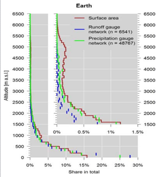
Altitudinal distribution of global runoff stations represented in the GRDC archive and global precipitation station network represented in the GPCC archive compared to global hypsography of the land surface area (without Greenland and Antarctica). The inset shows a magnification for altitudes above 1500 m.a.s.l. (Viviroli et al 2011).
|

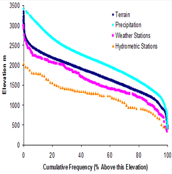
Hypsometric curve of cumulative frequency (or percentage above this elevation) for terrain area, volume of precipitation, number of weather stations and number of hydrometric stations as a function of elevation in the Canadian Rocky Mountain National Parks (UNESCO World Heritage Site) and a 50 km buffer zone around them (Pomeroy, Sinclair – in preparation).
|
Research in alpine catchments is complicated by the data scarcity of mountainous areas. Networks of meteorological and runoff stations become sparse as elevation and precipitation increase (Fig.1) and only a few elevated, well equipped research catchments are available. The global understanding of high mountain hydrology has been further impeded by a focus on local research or very topical cryospheric research (e.g. glacier, snow or permafrost studies) over decades. The development and testing of models, methods and algorithms has mainly been done at a few specific research sites and meaningful intercomparison exercises across mountainous regions of the world are scarce. The main reasons for this are that it takes a tremendous effort to operate and maintain high mountain research catchments and data exchange was and is a sensitive topic in many parts of the world. This complicates the development of transferable models and the implementation of international standards with respect to data quality and data documentation. However, there are research catchments for which the exchange of data is not restricted by formal or governmental regulations and these are amongst the catchments where the development of new methods, long-term databases of field measurements as well as the development of new measurement infrastructure coincide. For making the existent data and knowledge available to the community to foster future research, a concerted global effort is needed to address how changing high mountain hydrological processes will mediate the influence of atmospheric change in alpine catchments. This effort will also contribute to the more accurate dissemination of scientific findings to policy makers and stakeholders, regarding the relevance of mountain snowpacks and glaciers to water supply systems.
- Research Questions
The overall objective is to better understand alpine cold regions hydrological processes, improve their prediction and find consistent measurement strategies. To achieve this objective it is necessary to develop transferable and validated model schemes of different complexity that can support research in data sparse mountain areas. This leads to the following research questions relating to alpine hydrology and related snow and glacier studies and hydrometeorology:
-
How different are the measurement standards and the standards for field sampling and do we expect distinctive differences in model results and hydrological predictability because of the sampling schemes, data quality and data quantity?
-
How do the predictability, uncertainty and sensitivity of catchment energy and water exchange vary with changing atmospheric dynamics in various high mountain regions of the Earth?
-
What improvements to high mountain energy and water exchange predictability are possible through improved physics in land surface hydrological models, improved downscaling of atmospheric models in complex terrain, and improved approaches to data collection and assimilation of both in-situ and remotely sensed data?
-
Do the existent model routines have a global validity, are they transferable and are they meaningful in different mountain environments?
-
How do transient changes in perennial snowpacks, glaciers, ground frost, soil stability, and vegetation impact models of water and energy cycling in high mountain catchments?
- Data Requirements
Surface based data requirements for this project will primarily be met by
- openly-available detailed meteorological and hydrological observational archives from long-term research catchments at high temporal resolution (at least 5 years of continuous data with hourly sampling intervals for meteorological data, daily precipitation and streamflow, and regular snow and/or glacier mass balance surveys) in selected heavily instrumented alpine regions
- atmospheric model reanalyses
- downscaled climate model as well as regional climate model outputs
Instrumented sites, catchments and domains that investigators wish to make available to this project will be reviewed upon application as to how well they meet these requirements and encouraged to develop comprehensive high quality datasets. The ideal is for sites to be Integrated Alpine Observing and Predicting Systems (IAOPS). A provisional classification scheme for IAOPS is:
CLASS A: sites receiving technology transfer and developing towards CLASS B to E
CLASS B: Single measurement points with highly accurate driving data and snow or glacier data
CLASS C: gauged catchments that contain Class B sites and detailed vegetation coverage, soils, topography, snowcovered area, glacier mass balance or permafrost information
CLASS D: domains for which high resolution gridded meteorological data is available that includes CLASS C sites
CLASS E: the same as CLASS D but gridded meteorological data is also available as climate change scenarios.
High resolution atmospheric model runs (~2.5 km) will be needed by this project for domains centred around CLASS D IAOPS sites. The purpose of these runs would be to support experiments on dynamical downscaling of larger scale atmospheric model runs. The project will need access to regional climate model outputs such as NARCAPP in North America, but on a global coverage of mountain regions for CLASS E IAOPS sites.
- Project Methodology
The methodology is envisioned in several parts to cover the overall objectives and specific research questions.
- Facilitate an active exchange and collaboration between international researchers by forming a network of instrumented mountain catchments to compare instrumentation best practices, suggest improvements in instrumentation, and develop reliable alpine datasets for model testing and numerical experiments
- Evaluate process descriptions to improve algorithm development, conduct snow, glacier and permafrost hydrology process algorithm intercomparisons, define optimal parameterisations adapted to the different characteristics of the analysed catchments, and define structural, initial and boundary conditions. Uncertainty analyses will be conducted to properly quantify the reliability in representing alpine hydrological regimes in models
- Conduct cold regions hydrological model sensitivity testing to atmospheric change in various alpine environments and including sensitivity to including the effects of transient changes from glacier mass balance, groundwater changes and vegetation changes
- Demonstrate improvements to model predictability that can be realised from data assimilation, downscaling and model structural improvements
- Initialisation of different regional scale meteorological model setups and testing of different parameter sets in view of their ability to reproduce the observations
- Evaluation of different downscaling schemes for meteorological models on the basis of different datasets of the test sites. The evaluation should be not limited to the regular comparison of different meteorological parameters but should also include parameters like e.g. snowcover extent, snow water equivalent, soil moisture
- Foster research and development activities and coherent planning for future observing schemes and an international network optimization
- Facilitate education and training programmes to build and enhance capacities at various levels and popularize science results with the public
Integrated Alpine Observing and Predicting Systems (IAOPS), initial sites to be considered (a map of these and other relevant research basins is available here):
- Canadian Rockies Hydrological Observatory, Alberta, Canada
- Wolf Creek Research Basin, Yukon, Canada
- Schneefernerhaus and Research Catchment Zugspitze, Germany
- Arve Catchement, Col de Porte and Col du Lac Blanc Experimental Sites, France
- Dischma Research Catchment and SLF Weissfluhjoch Snow Study Sites, Davos, Switzerland
- OpAL Open Air Laboratory, Rofental, Austria
- Izas Research Basin, Spain
- Tarfala Research Catchment, Sweden
- Reynolds Creek Experimental Watershed, USA
- Upper Maipo and Upper Diguillín River Basins, Chile
- Upper Heihe River Basin, China
- Tibetan Plateau Research Sites (CAS), China
- Langtang Catchment, Nepal
- Collaboration Mechanisms
Proposed
- Initialisation of workshops to promote scientific integration
- Joint field and modelling experiments through scientific exchanges, resulting in multi-authored papers
- Joint development of an open-access Alpine Hydrological Modelling Toolbox
- Joint development of an open-access Alpine Downscaling Toolbox
- Promote the development of other catchments so that they can match the data availability requirements into the INACH initiative through scientific exchanges
- Snow hydrology model climate change sensitivity experiments with the Toolbox: Spain, USA, Germany, Canada (so far)
- Model snow process evaluation and algorithm intercomparison exercises using archived datasets to evaluate the prevalence and operation of various snow accumulation, redistribution and ablation processes in differing global alpine environments
- Contribute to UNESCO IHP efforts on climate change impacts on snow, glacier and water resources within the framework of IHP-VIII (2014-2021) 'Water Security: Responses to Local Regional and Global Challenges'
Details of past and upcoming meetings and other events are listed in detail on the Events page.
- Funding Needs
Collaborators in INARCH are expected to have their primary scientific research already funded under provisions that permit them to participate in and contribute to this project and to operate Integrated Alpine Observing and Predicting Systems. However, core funding to the project is needed to facilitate collaboration and central project operation through:
- Travel funding support for workshops, scientific exchanges, joint field and modelling experiments
- User support for and central modelling development of Modelling and Downscaling Toolboxes
- Data management of the data repository and model outputs for intercomparison experiments
- Outreach and training activities.
INARCH will be seeking these funds from appropriate agencies as it begins to operate on a collaborative basis
- Scientific Steering Group
The following participants have kindly agreed to serve on the network's initial Scientific Steering Group:
- Matthias Bernhardt (BOKU, Austria)
- Richard Essery (University of Edinburgh, UK)
- Ethan Gutmann (NCAR, USA)
- Tobias Jonas (SLF, Switzerland)
- Xin Li (CARERRI-CAS, China)
- Ignacio Lopez Moreno (IPE, Spain)
- Yaoming Ma (ITP-CAS, China)
- Danny Marks (USDA-ARS, USA)
- James McPhee (University de Chile, Chile)
- Thomas Painter (NASA JPL, USA)
- John Pomeroy (University of Saskatchewan, Canada)
- McKenzie Skiles (University of Utah, USA)
- Ulrich Strasser (University of Innsbruck, Austria)
- Vincent Vionnet (Meteo-France, France)
- ESSD Special Issue: Hydrometeorological data from mountain and alpine research catchments
|
|


