

|
|
|||
|
||||
 |
|||||||
Processes |
Theme 3 - Prediction The objective of Theme 3 is to evaluate and demonstrate improved prediction of hydrology, weather and climate at regional and smaller scales in the cold regions of Canada under varying land cover and boundary atmospheric conditions. Theme 3 Participants
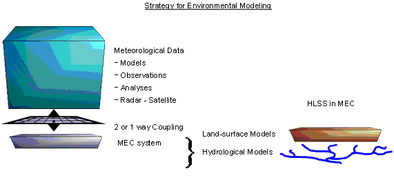
Modelling and Predictive Evaluation Strategy The modelling strategy employs a suite of process descriptions that deal with land surface hydrology, the regional atmosphere, numerical weather data, and coupled environmental models, the effect of which will be direct improvements to modelling capability. Observations are spatially distributed at the mesoscale, involving intensive observation periods with teams of investigators and their students and the use of existing federal and provincial observation networks. This strategy not only provides improved knowledge of the system components but also a better understanding of the interactions of the cryosphere, surface hydrology, atmosphere, and climate at a variety of scales from small to mesoscale. The construction of coupled hydrological and land-surface schemes (H-LSS), notably WATCLASS was initiated under MAGS and forms the basis for the development of the MEC system and subsequently for the MEC - Surface and Hydrology (MESH) modelling framework. The proposed model framework modularizes the H-LSS into four generic components: initialization, a tile (or GRU), a tile connector, and a grid connector. These components already exist within models such as WATCLASS, although they are not modularized in this fashion, which makes the current code (and conceptual framework) difficult to manage and develop.
According to this strategy, the conversion of WATCLASS to MESH requires effort in several areas. The assignment of basin information, parameters, and initial conditions is separated using the RPN coding standards used in MEC. CLASS remains a column model for each tile or GRU within a grid-square. Tile and grid connectors are built into existing WATCLASS code and are modularized by HAL. The project examines methods to improve all parts of MESH (initialization, tile processes, tile connector, grid connector) with particular emphasis on the tile processes and tile connector. Initialization: The model initialization is being updated in response to changes in the parameterisation of the model and for integration of the MESH system into the MEC modelling platform. Tile processes: New tile processes are proposed in this study. To test new model elements, the simulation results are being compared to as many other data as possible. These other data may consist of field measurements or the results of smaller scale models such as very fine scale finite element models or the Cold Regions Hydrological Model (CRHM). Comparison to these data sources will add confidence that the processes are being represented properly within the models. Tile Connector: The tile connector of the MESH system currently consists of a very simple aggregation of the results from the tile processes. This system does not allow for transfer of water between tiles before runoff is assumed to enter the stream. Various other strategies are being examined including a wetland buffer to intercept runoff before entering the stream channel, transfer of runoff between tiles in the “fill and spill” method as proposed by Spence, and the transfer of blowing snow between tiles. Grid connector: The grid connector in MESH is based on that used in WATCLASS. The program only routes flow volumes from and to successive grids. The IP3 approach is to combine the strength of top-down (inductive reasoning from basin behaviour) and bottom-up (deductive reasoning from general process relationships) modelling methods, by defining a set of basic hydrological response units at the subgrid level, typically but not limited to topographically-based hillslopes. Each grid is characterized by representative hillslopes that form the basis for the water and energy budget calculations. The philosophy is to treat the hillslope as a control volume represented by average state variables such as soil moisture and temperature and then to link these to the internal structure and to generate boundary conditions to determine the transfers between elements. This allows a rigorous link between microscale studies and mesoscale modelling. For example, slope and aspect can be explicitly represented to determine resistance factors. Examples of hillslope variables that are relevant are soil moisture and temperature profiles, and also the position of the wetting front and of liquid/ice interfaces.
Theme 3 Schedule and Milestones Year 1: Operational version of existing MESH model established for all research basin and NWP domains
Year 2: Incorporate new process and possible parameterisations into the MESH system
Year 3: On-going improvements of MESH with new algorithms on each research basin, and evaluate model performance with reference to measured mass and energy balances
Year 4: Evaluate performance of coupled models for major cold regions land covers
Theme 3 Deliverables It is anticipated that by the end of year 4, the following deliverables derived from the prediction aspects of this research will be achieved:
|
||||||||||||||||||||||
|
|||||||||||||||||||||||
|
IP3 Secretariat contact details This page last updated 28 May, 2010 |
|||||||||||||||||||||||