

|
|
|||
|
||||
 |
|||||||
Processes |
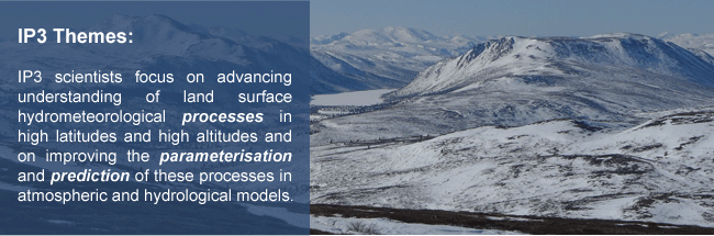
Theme 1 - Processes The objective of Theme 1 is to assess and improve our understanding of cold regions hydro-meteorological processes and their interactions with the atmosphere, hydrological system, and biophysical properties of the surface. Theme 1 Participants
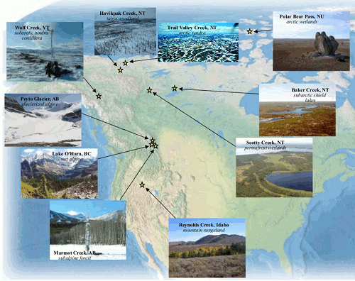
Field Observations Field observations will be carried out in IP3's 10 research basins, 14 to 195 km2 in area. The research basins are representative of the cryosphere in Western Canada, sampling the range along North-South and East-West transects from high altitude cordilleran sites in the south and west to low elevation basins in the north and east. This provides a great variety of cold regions vegetation, topography, climate, and precipitation regimes in which to develop and test new ideas. Research basin observations will not only be used to improve cold regions process representations but also to evaluate meso-scale representations in models and to assess model performance and sensitivity in multi-criteria prediction.
The research basins and the lead Investigator for each basin are listed below: Trail Valley Creek, NWT (Phil Marsh): Trail Valley Creek flows into the Arctic Ocean through the Eskimo Lakes system. Its area is 70 km2, it is primarily covered with sparse and shrub tundra and tundra ponds, and it is underlain by continuous permafrost. It has 3 permanent meteorological stations and two streamflow gauging stations. Havikpak Creek, NWT (Phil Marsh): Havikpak Creek flows into the Mackenzie River near the Delta. It is primarily covered with an open taiga woodland, open wetlands, and upland shrub tundra. The basin is underlain by continuous permafrost, some of which is ice-rich. It has two meteorological stations and a streamflow gauging station and is near the Inuvik MSC weather station. Polar Bear Pass, Nunavut (Kathy Young): Polar Bear Pass straddles the middle of Bathurst Island, has an exceedingly low regional gradient of about 0.0004 (2 m elevation range in >5500 m), and is bordered by hills up to 240 m high. The basin covers approximately 100 km2, and an automatic weather station provides historic meteorological data. This wetland is occupied by tundra ponds and lakes of various dimensions as well as several minor but definable streams. Baker Creek, NWT (Chris Spence): Baker Creek is a series of interconnected lakes draining an area of 150 km2 north of Great Slave Lake that is typical of Canadian Shield drainage basins. The landscape is taiga woodland and boreal forest. It has three meteorological stations and one streamflow gauging station. Wolf Creek, Yukon (Sean Carey): Wolf Creek is part of the headwaters of the Yukon River near Whitehorse, Yukon Territory. Its area is 195 km2 and it has a sub-arctic climate with vegetation zones ranging from boreal forest to windswept alpine tundra. The basin is partially underlain by permafrost. It has six permanent meteorological stations ranging in elevation from 750 to 1600 m and three gauged sub-basins. Scotty Creek, NWT (Bill Quinton): Scotty Creek flows into the Liard River near its confluence with the Mackenzie River at Fort Simpson. It drains a broad permafrost wetland with islands of sparse woodland surrounded by open fen and muskeg. It has 2 meteorological stations and is near the Fort Simpson MSC weather station. Peyto Creek, Alberta (Scott Munro): Peyto Creek drains a 24 km2 basin in Banff National Park that forms part of the headwaters of the North Saskatchewan River. The basin is 60% covered by the Peyto Glacier which has been the subject of intensive mass balance, energy balance, and runoff observations since the basin’s adoption as an International Hydrological Decade (IHD) research site in 1965. The basin has an automatic weather station adjacent to the glacier, a glacier mass balance field programme that is part of the National Glaciology Programme of NRCan, and a streamflow gauge. Marmot Creek, Alberta (John Pomeroy): Marmot Creek feeds the Kananaskis River and the Bow River system from the Rocky Mountains. Its area is 14 km2 and it is primarily covered with montane and sub-alpine forest with alpine tundra ridgetops. The basin has been subject to intensive hydrometeorological studies since the International Hydrological Decade. It has 8 permanent meteorological stations at elevations from 1450 m to 2500 m, and observations of groundwater levels and streamflow are made by the federal and provincial governments. Lake O’Hara, BC (Masaki Hayashi): The Lake O'Hara basin is 14 km2 in size and ranges in elevation from 2010 to 3490 m. Three small glaciers occupy approximately 5% of the basin. The basin currently has two meteorological stations and five stream gauging stations. Dr. Hayashi has written a brief description of the groundwater pathways in the Lake O'Hara Basin for the Lake O'Hara Trails Club. Reynolds Creek Experimental Watershed, Idaho, US (Danny Marks): The Reynolds Creek Experimental Watershed is a 239 km2 drainage in the Owyhee Mountains that has been operational since 1960. Research is currently supported by 9 weirs, 37 meteorological stations, 26 precipitation stations, 8 snow course and 5 snow study sites, 5 eddy covariance systems, and 27 soil microclimate measurement locations.
Process Algorithms Process algorithms dealing with snow and glacier ice, open water, and runoff generation are being developed using spatially nested coupled mass and energy observations in the research basins. Observations include sensible and latent heat exchange, radiation exchange, snow mass change, blowing snow mass flux, precipitation, snowmelt, ground heat flux, advection, soil thaw, overland flow, sub-surface flow, soil moisture change, and streamflow. In most basins these occur at several locations and the issues of spatial variability in fluxes are addressed by multiple observations using various hydrological and meteorological variables. Measurement of these variables is via flow lysimeter, time domain reflectometry (for soil moisture observations), and both permanent and mobile networks of eddy covariance instrumentation to collect sensible and latent heat fluxes, wind speed, air temperature, humidity, snow depth, precipitation, and radiation. Soil temperature and both large and small profile observations of heat and moisture gradients are also measured. Investigators work in teams with pooled equipment for focussed field campaign in each basin to ensure common methodologies and critical mass. Because the basins cover significantly different topography and climate, algorithms are tested at multiple basins to ensure robustness and transferability suitable for hydrology and land surface schemes.
Theme 1 Schedule, Milestones, and Deliverables Year 1:
Year 2:
Year 3:
Year 4:
|
|||||||||||||||||||||||||||||||||||||||||||||||||||||||||||||||||||||||||||||||||||||||||||||||||||||||||||||||
|
||||||||||||||||||||||||||||||||||||||||||||||||||||||||||||||||||||||||||||||||||||||||||||||||||||||||||||||||
|
IP3 Secretariat contact details This page last updated 28 May, 2010 |
||||||||||||||||||||||||||||||||||||||||||||||||||||||||||||||||||||||||||||||||||||||||||||||||||||||||||||||||