|
Theme
3 - Prediction
Theme Lead: Alain Pietroniro,
University of Saskatchewan
and
Environment Canada
(e-mail, www)
The objective of Theme 3 is to test and improve weather, water, and climate
models leading to enhanced prediction and simulation of related atmospheric
impacts on water resources, atmospheric fluxes, and surface climates in cold
regions.
The theme aims to achieve this goal through a combination of
observational, experimental, theoretical, and modelling studies at a range of
appropriate spatial and temporal scales developed in Theme 1 and
Theme 2.
The IP3 approach combines the strength of bottom-up (deductive reasoning from
point-scale process relationships, or 'microscale studies') and top-down (inductive reasoning from
large-scale basin behaviour, or 'mesoscale modelling') modelling methods. These two methods
meet conceptually in the middle, through definition of the Hydrological Response
Units (HRUs) described in Theme 2.
By combining land surface hydrology models, regional atmospheric models, numerical
weather prediction models, and coupled environmental models, we are able to examine the influence of varying land cover and boundary atmospheric conditions at
multiple scales, from local to regional (10s of km to 1000s of km). This
approach is resulting in improvements to water resource modelling
capability, providing better modelling structure, more coprehensive physical
description, and therefore improved parameterisation. Particular areas of
improvement include representation of the
interaction of soil moisture and evaporation, optimisation of land-surface
parameters using streamflow hydrographs, and the parameterisation of cold region
processes including permafrost, frozen soil, snow sublimation, and snow
redistribution by wind and vegetation.
IP3's 'strategic' model is based on a configuration of Environment Canada's
Modélisation Environmentale Communautaire (MEC), a 'community
environmental modelling system' which facilitates integration between individual
models representing different components of the earth system. The configuration
used by IP3,
MEC - Surface and Hydrology (MESH), couples
independent hydrological and atmospheric models, so that modelled land-surface
hydrological behaviour influences and reacts to the atmosphere just as weather
and water co-exist in the natural world. New components (including new
parameterisations) which are to be incorporated into MESH and the other
predictive models are tested by comparing simulation results to as many
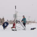
other datasets as possible. These may be field measurements, or the results of
more local models, such as very fine scale finite element models, or CRHM.
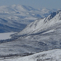
Modelling domains have been established at three different scales for western
Canada, with each being represented by a different predictive model.
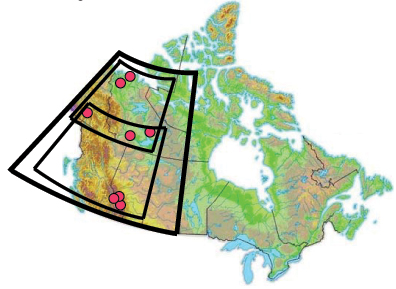
The CRCM domain is established over all of
western Canada (thick black line);
GEM-north and GEM-south are
established over the CRCM domain (thin black
lines);
MESH domains focus on the eight research basins (red circles)
Regional Resolution
The Canadian Regional Climate
Model (CRCM) is being used to provide synthetic climate data over western Canada. The CRCM is a numerical integration scheme for
computing atmospheric flow and is generally used at large spatial scales and
coarse resolution. It is very useful for examining the regional impacts of
climate change and variability.
Intermediate Resolution
The Global Environmental Multiscale (GEM) model, currently used
at Environment Canada for numerical weather prediction such as weather
forecasting, is being run as a Limited Area Model (GEM-LAM) over
two domains, GEM-North and GEM-South. GEM-LAM operates at intermediate
resolution and thus bridges regional simulations from CRCM and basin-scale
simulations from MESH.
Basin-Level Resolution
MESH has been established and is being run over all eight IP3 basins at
increasingly high resolutions. As described above, MESH combines atmospheric
modelling with land-surface and hydrological modelling. These predictive models
are designed to be used in both hindcasting and forecasting modes.
The two other models in the IP3 modelling hierarchy are CRHM and CLASS.
The Cold Regions Hydrological Model
(CRHM)
is being used as a method to test parameterisations, which may then be improved and
incorporated into the larger-scale predictive models, GEM and MESH; it
is also a predictive tool in its own right. The simple user interface of CRHM makes
it useful for training and for development of purpose-built physically-based
basin models which rely on zero or minimal calibration. CRHM is available
to all interested users as a technology transfer component to IP3.
The Canadian
Land Surface Scheme (CLASS) is used as either a stand-alone land surface scheme
or as part of the MESH, GEM, and CRCM models. The current versions of CLASS and
MESH have not been widely tested in complex topography or cold regions, so it is
IP3's mandate to evaluate and improve these models for operational applications
in Canada.
IP3 Collaborator James Craig is involved in the
Environmental Modelling and Analysis Group at the University of Waterloo.
His work focuses on numerical and semi-analytical approaches for modelling
surface and groundwater flow.
Further details are available from the IP3 Models page.
Theme 3 Timeline:
2007
Operational version of existing MESH model established for all research
basin and NWP domains
- Review current modeling and data status in meso-scale and regional
research basins
- This would include establishing GEM-LAM domains for each of the research
domains that incorporate the MESH system for hydrological routing and basin
segmentation (tiles, tile connectors and grid connectors)
- These simulations will be based on existing Water Survey of Canada and
exiting climate and synoptic stations gauge locations within the domain
2008
Incorporate new process and possible parameterisations into the MESH system
- Establish and evaluate water and cycle predictions derived from the MESH
modelling domains using primarily the CLASS land surface model and existing
routing models
- Perform sensitivity analysis of atmospheric fluxes and prognostic
predictions, as well as through comparison with observed hydrographs. Where
possible, the model predictions will be compared with key variables such as
discharge, surface water storage, water balance, snowcover, soil moisture,
soil frost, soil heat flux, evaporation
2009
On-going improvements of MESH with new algorithms on each research basin, and
evaluate model performance with reference to measured mass and energy balances
- Re-evaluate regional hydrological response based on improved
parameterization from research basins and IP3 field studies
- The prediction team will work closely with the research teams in P1 and P2
to evaluate the relative importance, sensitivity and cumulative effect of
introducing algorithms, parameterizations and new landscape segmentations
derived through field and basin experiments.
2010
Evaluate performance of coupled models for major cold regions land covers
- This will include incorporating cryospheric process numerical descriptions
into land surface schemes coupled to a hydrological model to produce a coupled
modelling system that will provide a comprehensive simulation of the
terrestrial cryospheric system and its interaction with hydrology and the
atmosphere
- Simulate terrestrial water and energy cycles for the selected cold regions
environments
Theme 3 Deliverables
It is anticipated that by the end of year 4, the following deliverables
will have been derived:
- Integrated hydrology-land surface model (MESH). IP3 program will
have assessed the feasibility, scientific and technical considerations
required for implementation of the MESH system within the NWP modelling
framework of Environment Canada. Because IP3 researchers will be developing
MESH within the existing EC modelling framework, all IP3 work will be easily
transferable to operational model runs at a later date if so desired by CMC
- Improved Prediction in Ungauged Regions. Uncertainty in
hydrological prediction in ungauged regions is largely due to the
impossibility of parameterising models using gauged streamflow. IP3 will
improve our understanding in high latitude and altitude regions and use
landscape-based parameters resulting from detailed field studies rather than
the traditional top-down approaches. Landscape based parameterization will
allow rigorous methods of parameter selection and transferability, previously
unattainable in most hydrological modelling systems
- Improved Weather Prediction. It is well understood that feedback
from the land-surface to the atmosphere can be a critical control in local
weather phenomenon, however assessing the magnitude and importance of
land-surface feedbacks is still poorly understood. IP3 will provide the
definitive assessment in cold regions and will be the first systematic attempt
to quantify the importance of land-surface feedback in cold-regions
|
Participants |
|
|
Bruce Davison |
Environment Canada |
|
Richard Essery |
University of Edinburgh, UK |
|
Vincent Fortin |
Environment Canada |
|
Murray Mackay |
Environment Canada |
|
Alain Pietroniro |
University of Saskatchewan |
|
John Pomeroy |
University of Saskatchewan |
|
Ken Snelgrove |
Memorial University of Newfoundland |
|
Ric Soulis |
University of Waterloo |
|
Chris Spence |
University of Saskatchewan |
|
Diana Verseghy |
University of Waterloo |
|